BRPS are a member of the Thames Valley Angling Association which gives our members the opportunity to fish a number of different waters in the Thames Valley Area which are not directly leased by BRPS.
When fishing TVAA waters please ensure that you have with you your BRPS membership card and abide with the TVAA general and specific fishery rules. The general rules are listed below.
General rules applicable to all TVAA fisheries.
- All fish are to be returned.
- No litter.
- No cutting of trees or bank side vegetation.
- No bonfires or barbeques.
- Anglers must be in possession of a current Environment Agency rod licence and abide by all EA Bye-laws.
- Two rods maximum to be in use at any one time.
Also see Fishery Specific Rules listed next to fishery maps.
To prevent the spread of fish diseases, non-native fish and water organisms all anglers are requested to abide by the `Check, Clean, Dry` campaign. See the NNSS web site for more information www.nonnativespecies.org or download this information sheet Bio-security for Anglers .
If fishing the River Thames you may want to check river levels, temperatures etc prior to leaving hoome, the following Environment Agency websites provide this information:
Telemetry data Graphs showing the water clarity, oxygen levels and temperature over the last seven days.
River levels Graphs showing the Thames river levels at many points between Hurley and Teddington over the last 48 hours.
The TVAA fisheries
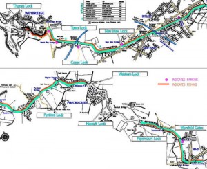 Wey Navigation
Members have access to approximately 7 miles of the Wey Canal and a short section of the River Wey just before it joins the River Thames owned by the National Trust. This is reported to be an excellent winter fishery for roach and bream and does in fact host winter league matches. Members wishing to fish the canal, particularly at a weekend, should check on the TVAA website using this link to see which, if any, sections have been booked for matches. Even if matches are being held there should be plenty of bank space available on other sections of the canal.
See fishery maps right (click to enlarge).
From Worsfold Gates at Send to Papercourt Lock and Walsham Lock to Weybridge. Approximately 7 miles in total.
Parking
As indicated on map and in geographical order starting at Weybridge and going upstream, ending at Send.
- Weybridge, access to, Sect 1 (actually the R Wey) and Sect 2a (Eastend)
Weystone Rd, KT13 8XX, Limited Parking in a small public car park - Blackboys Bridge, Weybridge, access to Sect 2a (Westend), Sect 2b (Eastend)
Addlestone Rd, KT15 2RX, Park on bridge (DO NOT BLOCK Farmers access across bridge) and on edge of road. - Addlestone Mill, Addlestone, access to Sect 2b (Westend), Sect 3 (Eastend)
Bourneside Rd KT15 2JX, Park in Parking bays, DO NOT BLOCK Residents access. - New Haw, access to Sect 3 (Southern end) and Sect 4a (Northern End)
Byfleet Rd, KT15 3JX, Park in service road parallel to canal. - Parvis Bridge, Byfleet, access to Sect 4b (Southern end) and Sect 5 (Northern end)
Old Parvis Rd, KT14 6LE, Park on edges of the bridge, DO NOT BLOCK THE TURNING BAY - Anchor, Byfleet, access to Sect 6 (Southern end) and Sect 7 (Northern end)
Wisley Lane, GU23 6QW, VERY limited parking, DO NOT USE PUB CAR PARK unless you use the pub - Tannery Lane, Send, access to Tannery lane section north and south
Tannery Lane, GU23 7EF, plenty of parking in carpark. - New Inn, Send, access to top end of Tannery stretch and New Inn stretch
Broadmead lane, GU23 7AE, Limited parking on roadside, DO NOT BLOCK residents access.
Thanks to Dave Blackmore for this information.
Fishery Specific Rules
- Fishing is dawn to dusk only
- Fishing is 16th June to 14th March only
- All fish to be returned
- No vehicles on the towpath
- Any signal crayfish or Chinese mitten crabs caught must not be returned
- No fires
- Do not alter the profile of the bank or cut or create any steps
- Do not obstruct the tow path
- Do not fish within 50 metres either side of any lock prior to 1st October in every season.
- Do not fish between Pyrford Lock and area opposite the entrance to Pyrford Marina (Wey)
- No livebaiting for Pike etc.
- You must produce your club membership card if asked by National Trust staff.
Day Tickets available from Weybridge Guns & Tackle – 01932 842675, Apollo Angling Centre – 01932 355100, Goldsworth Angling – 01483 776667
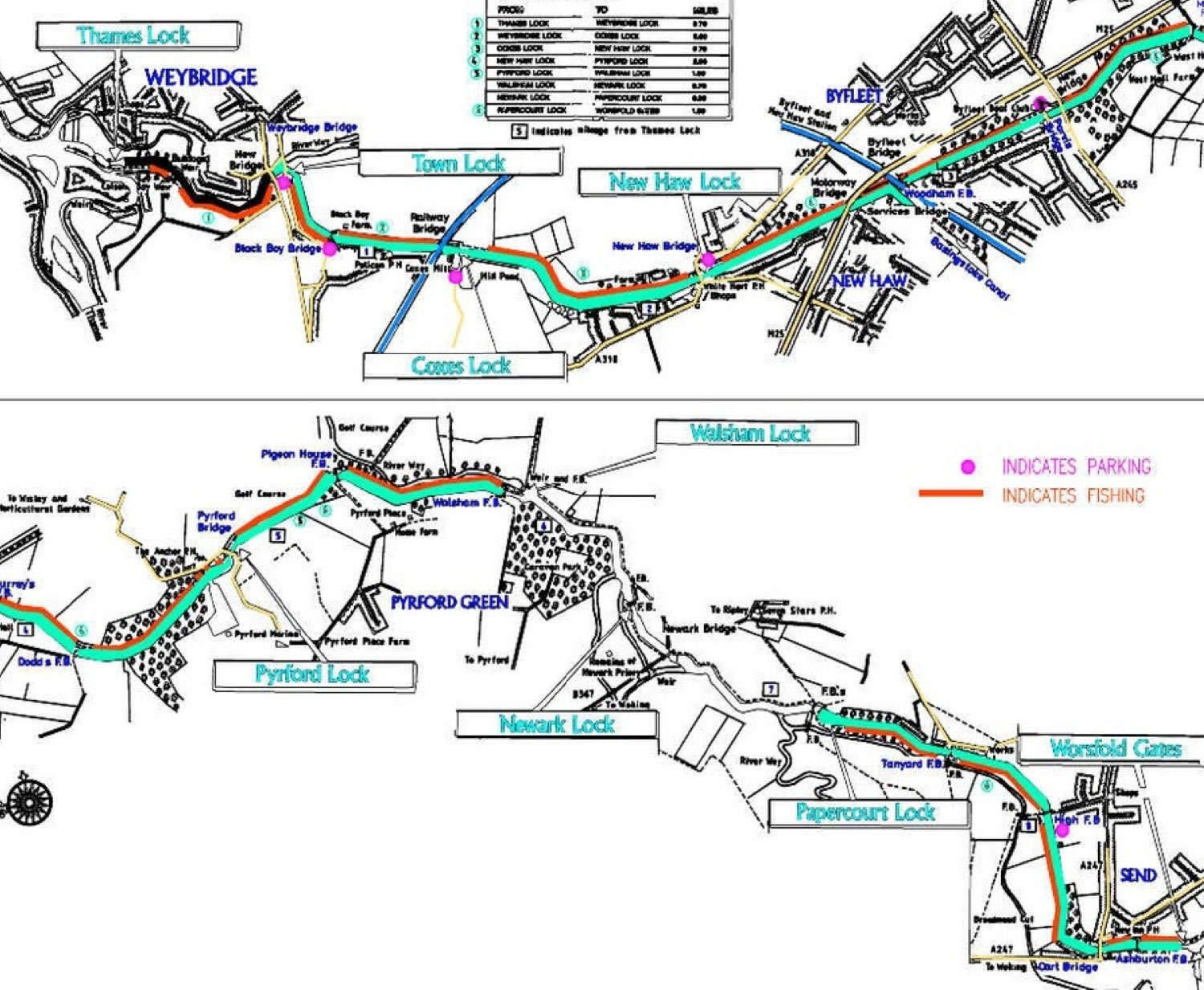
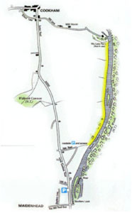 River Thames Cliveden
A pleasant section of the River Thames located between Cookham and Maidenhead reportedly providing good roach and dace fishing. The fishery extends from My Lady Ferry downstream on the right bank (looking downstream) to Islet Road.
Parking
Parking is available in Islet Road, post code SL6 8LE or in the public car park at Boulters Lock, post code SL6 8JB.
See fishery maps right (click to enlarge).
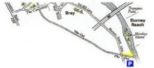 The Cut Bray

The Cut is a small side stream from the Thames adjacent to Bray Marina extending from Monkey Island Lane down to the Cut’s junction with the River Thames. The cut can fish well when the Thames is in flood.
Parking
Parking is in the layby on Monkey Island Lane just before the bridge over the Cut, post code SL6 2EB.
See fishery maps right (click to enlarge).
 The Jubilee River
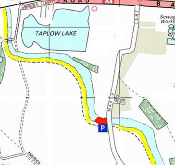
This is a right hand bank fishery (looking downstream) extending upstream from the M4 road bridge to the wooden foot bridge off Amerden Lane. This is quite a long section of the Jubilee River and can produce roach, dace and good sized bream. NOTE at weekends there are swimmers from a local club that swim from Marsh lane up stream to the woodern bridge and back again, This normaly takes about an hour and they swim mid water.
Parking
Parking is in the public car park off Marsh Lane, post code SL6 0DF, the fishery extending both upstream and downstream of this point. This car park may get busy at weekends due to swimmers and walkers .
See fishery maps right (click to enlarge).
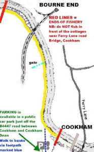 River Thames Cookham
This stretch of the Thames is available to TVAA members by courtesy of Cookham AC. The right bank fishery (looking downstream) extends from the marina in Cookham upstream to approximately 400 yards above the railway bridge.
See fishery maps right (click to enlarge).
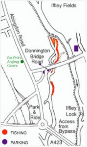 River Thames, Weir Stream Oxford
Approximately 1000 m of River Thames back stream including a weir located downstream of Donnington Bridge. Post Code OX1 4UR.
Limited parking is available in adjacent roads.
See fishery maps right (click to enlarge).
Fishery Specific Rules
Night fishing is permitted on this fishery. No night fishing near the house boats, please keep quiet. All TVAA members fish this water as guests of the Complete Tanglers Angling Club.
 River Thames – Roundmoor Ditch to Clewer Meadow
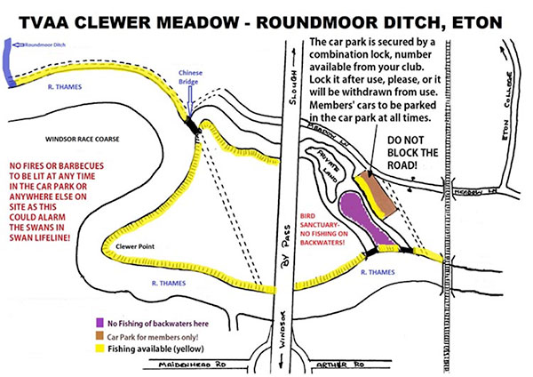
Over a mile of left bank fishing extending from the junction of the Roundmoor Ditch with the River Thames at Eton Wick downstream to the railway bridge at Eton including a section of river and Thames backwater known as Clewer Meadow.
Clewer Meadow was reputed to be a good fishery in the past particularly in high water conditions. The upstream end of the fishery is opposite the Civil Service stretch at Windsor Race Course which is also reputed to be a good fishery.
Directions and Parking
From the traffic lights in the middle of Eton take the B 3026 towards Eton Wick.
To access the downstream end of the fishery and the TVAA car park at Clewer Meadow take the left hand turning in less than 100 yards from the traffic lights, as the road turns abruptly to your right, into South Meadow Lane. At the ‘T’ junction with Meadow Lane turn right into Meadow Lane. The car Park is on your left just after you have gone underneath the railway line. Access to the car park is via a locked gate, please obtain the combination from one of our bailiffs or our Hon Secretary before going to the fishery if you wish to use the car park. Please ensure that you then lock the car park and scramble the combination.
Access to the upstream end of the fishery is from Eton Wick, after entering the village from Eton take a turning on the left and find somewhere to park near the Recreation Ground and then walk down to the river.
See fishery maps right (click to enlarge).
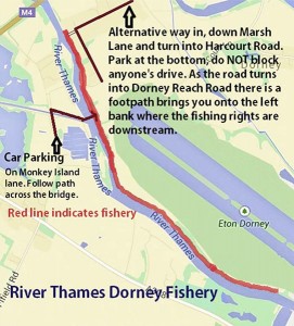 River Thames – Dorney
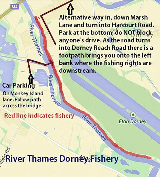
Approximately a mile of left bank fishery extending downstream from opposite Monkey Island to Windsor Marina on the opposite bank, see map. When we last had access to the fishery there was a good head of roach, dace and perch. In addition pike, chub, barbel, bream and a very occasional brown trout are present.
Directions and Parking
Access to the fishery is possible from either side of the river. From the north side if coming from Eton Wick continue on to Dorney on the B 3026 and at the far end of the village turn left into Court Lane and then follow the road to the right, Marsh Lane. Don’t go straight on into the rowing complex. When you come to the first set of houses on the left, turn left into Harcourt Road, follow this road until you join Dorney Reach Road which turns to the left. A short distance down Dorney Reach Road on your right there is a narrow footpath between two gardens, this takes you down to the river. When parking please take care not to block access to any of the houses.
From the south side of the river from Windsor take the A 308 towards Maidenhead, carry on past Oakley Court on your right and a filling station on your left and just before entering Bray turn right into Monkey Island Road. Carry on past the entrance to Bray Marina and then park your car in the space on the right. From here walk further down the lane and then after crossing the cut turn onto footpath to your right. Continue down to the river and cross over the footbridge.
See fishery maps right (click to enlarge).
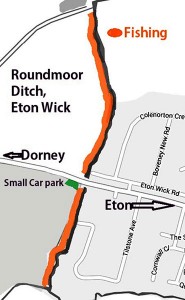 Roundmoor Ditch – Eton Wick

This is a relatively short section of small stream fishery which can provide surprisingly good fishing under the right conditions, particularly in winter with relatively large bags of roach and dace. The fishery also turns up the occasional chub, babel, perch and pike.
Directions and Parking
From Eton follow the B3026 to Eton Wick, at the far end of the village you pass over the Roundmoor Ditch. There is space to park a couple of cars immediately on your left after crossing the stream, alternatively park in the housing estate on your right just before you get to the stream. Please ensure you do not block anyone’s access if parking here.
See fishery maps right (click to enlarge).
 Jubilee River – Lake End Road to M4
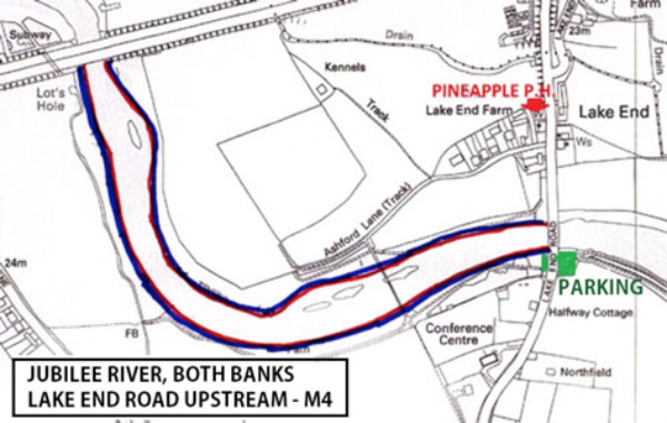
This fishery extends for approximately a mile from Lake End Road upstream to the M4 on both banks. In common with much of the Jubilee River this section has been relatively under fished since the Jubilee River was built. The upstream limit of this fishery forms the downstream limit of the other TVAA Jubilee River fishery. The Jubilee River reputedly holds a head of roach, perch, bream and pike.
Directions and Parking
From the M4 westbound exit at Junction 7. At the first roundabout turn left onto the A4 Bath Road heading west. Proceed along the A4 until you reach the roundabout next to Sainsbury’s, turn left onto the B3026, Lake End road, towards Dorney. Proceed on this road past the Pineapple pub and then cross the Jubilee River, there is a small car park on your left immediately after you have crossed the Jubilee River, Park here. The fishery extends on both banks upstream of the bridge.
From Eton proceed on the B3026 through Eton Wick then Dorney until you reach the Jubilee River, the car park is on your right immediately before the Jubilee River.
See fishery maps right (click to enlarge).